
Related Links:
A RETROSPECTIVE ANALISYS OF A SOIL GAS SURVEY OVER A STRATIGRAPHIC TRAP TREND ON THE KANSAS-COLORADO BORDER
CASE STUDY OF DEVELOPMENT DRILLING AT MOORE-JOHNSON FIELD BEFORE AND AFTER AN EXPLORATION SOIL GAS SURVEY
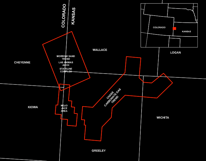
Morrow Stateline Trend, Greeley Co., Kansas
REGIONAL SOIL GAS SURVEY
CHASE CARBONATE GAS TREND, BYERLY AND BRADSHAW FIELDS
Hugoton Embayment, SW Kansas
HUGOTON EMBAYMENT,
SE COLORADO AND SW KANSAS
CHASE CARBONATE GAS TREND
A large detailed regional soil gas survey is available for sale in the
prolific Chase Carbonate Gas Trend of the Hugoton Embayment of SW Kansas.
The seven-foot soil gas survey covers an area of about 210 square miles
and consists of 923 soil gas sites. This regional soil gas survey is located
to the west and north of Bradshaw (334 BCFG) and Byerly (47.3 BCFG) Gas
Fields. A number of untested soil gas anomalies exist that are on trend
with established Chase Carbonate gas production
Chase Carbonate Gas Trend Location
Map (923 sites)
MORROW STATELINE TREND
A large detailed regional soil gas survey is available for sale in the
prolific Morrow Sand Stateline Trend (100 MMBO, 500 BCFG) of Colorado
and Kansas. This soil gas survey consists of data from 1832 four-foot
soil gas sites over an area of more than 200 square miles. The geochemical
survey provides continuous microseep coverage over a north-south distance
of 30 miles extending from Arapahoe Field in the north to Moore-Johnson
Field in the south. Soil gas sample density varies from 11 to 16 sites
per section.
Morrow Sand Stateline Trend Area Location
Map (798 sites)
Mojo Jace Area Location Map (1034 sites)
Contact Information:
e-mail:etimail@eti-geochemistry.com
A RETROSPECTIVE ANALISYS OF A SOIL GAS SURVEY OVER A STRATIGRAPHIC TRAP TREND ON THE KANSAS-COLORADO BORDER
Dickinson, Roger and Uhl, D.A., Texaco E&P, Denver, Colorado;
Matthews, M.D., Texaco Frontier Exploration Department, Bellaire, TX;
LeBlanc, R.J., and Jones, V.T., Exploration Technologies, Inc., Houston, TX
AAPG Hedberg Research Conference
Near-Surface Expression of Hydrocarbon Migration
April 24-28, 1994
Vancouver, British Columbia, Canada
In 1987, Texaco collected a grid of soil gas samples over a 150 square mile area on the Kansas-Colorado border. This survey is on the northeast flank of the Las Animas Arch. Within the study area, the dominant productive horizon is the Lower Pennsylvanian Morrow Formation. The Morrow sandstones were deposited in erosional channels (valley fills) that today are found at depths ranging from 5000 to 5500 feet. The survey included what was then the Stockholm field and a few very small fields. Additional exploration and development drilling in the area has established a significant productive trend, now known as the State Line Trend. The Stockholm Field contains 82 wells, and produces from the Morrow Formation sandstones, with an average productive interval of 18 feet and a maximum of 60 feet. Porosities reach 20% and permeabilities average 217 md. The State Line Trend now contains 8 fields, is over 35 miles long, with an estimated primary recovery of 35 million barrels, and additional secondary potential.
A total of 798 samples were collected in the survey area, on a sample grid of five samples per mile. Overall hydrocarbon magnitude of the samples was low (median methane=0.749, ethane=0.013, propane=0.007 ppm) compared with world clear air (methane=1.6, with ethane and propane below 0.01 and 0.05 ppm) or other soil gas surveys. The overall low magnitudes caused a great deal of concern about the validity of the resulting anomaly patterns and the use of micro-seep techniques in an intercratonic sag basin. Additional concern was caused by the lack of any apparent agreement between the location of methane anomalies and those found on the ethane or propane maps. The samples were thought to be of low magnitude because of a lack of abundant fractures and faults to provide active migration paths to the surface. Shallow biogenic sources are thought to be contributing to the methane magnitudes over the survey area.
Since the survey was conducted, the area has been developed into a significant complex of productive fields. Approximately 80 productive wells were within the survey area in 1987. At the end of 1993, there were 270 productive wells in the survey area.
Re-examination of the data in the context of the post survey drilling illustrates the value the survey could have provided in (and prior to) 1987. While the ethane and propane anomalies do not predict specific prospects/drillsites, the major anomalies are closely associated with productive trends. This association indicates the value of soil gas surveys as a reconnaissance tool in and around the State Line Trend.
LIST OF FIGURES
Location Map
Structure Top Morrow Formation
Stratigraphic Section
Stateline Complex Development - January 1987
Soil Gas Conducted - November 1987 - Ethane Magnitude Contour Map
Stateline Complex Development - August 1990
Stockholm Field - Wallace and Greeley Cos., Kansas
Stockholm Net Sand - Isopach Map
Stockholm Field - Soil Gas Survey - Ethane Magnitude Contour Map
A case study is presented that documents development drilling at Moore-Johnson (MoJo) Field in Greeley Co., Kansas both before and after an exploration soil gas survey was conducted by Exploration Technologies, Inc. (ETI) in April 1992. ETI conducted a proprietary four-foot exploration soil gas survey for a client in the area during April 1992 (Figure 1). The soil gas survey, consisting of 1034 sites, was conducted over a very large area from just south of Second Wind Field in Cheyenne Co., Colorado to two miles south and 5 miles southeast of MoJo Field in Greeley Co., Kansas (Figure 1). The 53 square mile area of the soil gas survey was conducted at the time when there were only 3 producing wells in MoJo Field. A portion of the soil gas data from this survey is presented in a four square mile area around MoJo Field (Figure 2).
MoJo Field in Greeley Co., Kansas was discovered in 1989. The oil wells were completed in the sands of the V-7 valley fill sequence of the Morrow Formation. This interval in the Morrow Formation was initially named the Stockholm Sand. By April 1992, 8 wells had been drilled in the immediate area of MoJo Field consisting of 3 producing wells and 5 dry holes (Figure 2). The purpose of the soil gas survey was threefold: (1) calibration of the survey to the production at MoJo Field, (2) to aid in further development drilling at MoJo Field, and (3) to determine other areas along trend that exhibited soil gas microseepage and therefore would have exploration
potential.
An ethane concentration contour map, constructed from soil gas analytical data in the vicinity of the present day MoJo Field, is included as Figure 3. There are 14 new producing oil wells (drilled since April 1992) and they are located both east and north of the original 3 producing oil wells of MoJo Field and are located within the ethane soil gas anomalies (Figure 4).
There are presently 17 producing wells in MoJo Field (Bowen and Weimer, 2003). During development drilling after the soil gas survey (April 1992 to present day), in addition to the 14 new oil well completions, 7 additional dry holes were drilled. Clearly, 4 of these 7 dry holes (3 wells along the west edge of the field and 1 well in the northwest end) are definitely outside of any ethane soil gas anomalies and have no basis for being drilling based solely on geochemical data (Figure 4).
The success ratio at MoJo Field prior to the soil gas survey was 37% (3 productive wells, 5 dry holes; see Figure 2). This is considered a somewhat poor success ratio for development/exploitation drilling. Success ratio at MoJo Field after the soil gas survey was 82% (14 productive wells and 3 dry holes). This calculation disregards the four dry holes mentioned above that were not near geochemical soil gas anomalies. Therefore a case can be made that the soil gas survey increased the success ratio at MoJo Field by a factor of 2.2.
Reference
Bowen, D.W., and Paul Weimer, 2003, Regional sequence stratigraphic setting
and reservoir geology of Morrow incised-valley sandstones (lower Pennsylvanian),
eastern Colorado and western Kansas: AAPG Bull., v 87, n 5, p 781-815.
CHASE CARBONATE GAS TREND, BYERLY AND BRADSHAW FIELDS
Hugoton Embayment, SW Kansas
A large detailed regional soil gas survey is available for sale in the prolific Permian Chase Carbonate Gas Trend of the Hugoton Embayment of SW Kansas. The seven-foot soil gas survey covers an area of about 210 square miles and consists of 923 soil gas sites (Figure 1). The soil gas survey was sampled on a box grid pattern with a one-half mile distance between samples. An average section (640 acres) contains nine soil gas sample sites.
This regional soil gas survey is located in Greeley and Wichita Counties, Kansas to the west and north of Byerly (47.3 BCFG) and Bradshaw (334 BCFG) Gas Fields. A portion of the soil gas survey was conducted over the northwest half of Byerly Field for calibration purposes. The Permian Carbonate Gas Play (Chase and Council Grove Groups) in the Hugoton Embayment is the most prolific and important hydrocarbon play in this petroleum province. This area of SW Kansas is also referred to as the Hugoton gas area (Figure 2). The major gas fields of this area – Hugoton, Panoma, Greenwood, Bradshaw, and Byerly have produced a total cumulative of 27 TCFG.
Byerly and Bradshaw Gas Fields, together, have a total cumulative production of 381 BCFG from the Chase Carbonate reservoir. Byerly Field was discovered in 1968. Development drilling at Byerly Field (Figure 3) progressed rapidly through the 1970’s up to 1985 when the field reached a maximum development of 55 wells. There was a hiatus in development drilling from 1986 until 1990. Since 1990 there have been 14 Chase Carbonate completions at Byerly Field. There are currently 46 producing gas wells in the field of which 20% have been completed since 1995. Interpretation of the analytical data from the soil gas survey within NW Byerly Field indicates that there some additional areas for further development drilling within the field area.
The natural gas accumulations at Byerly Field are due to stratigraphic entrapment caused by a facies change in the Permian Chase Carbonate reservoir where it grades from limestones and dolomites in the east to nonmarine red beds in the west (Figure 2). Regional dip of the Chase Carbonate is to the east-southeast. The upper seal for the gas reservoirs are provided by anhydrites and shales of the overlying Sumner Group. Average drill depths of the gas reservoir at Byerly Field range from about 2750 to 2900 feet. Porosity and permeability in the Chase Carbonate are highly variable as evidenced by the cumulative gas production from individual wells (Figure 3). Cumulative gas production from wells in Byerly Field range from 30 MMCFG to 3,572 MMCFG.
The stratigraphic entrapment of the gas, relatively shallow depth, and highly variable porosity and permeability of the reservoir are factors which favor the application of surface soil gas surveys as an important exploration method to reduce risk in this play.
The purpose of the regional soil gas survey was threefold: (1) calibration of the survey to the gas production at Byerly Field, (2) to aid in possible further exploitation/development drilling at Byerly Field, and (3) to determine other areas along trend that exhibited anomalous soil gas microseepage and would therefore indicate areas of exploration potential.
The variability of the cumulative gas production from individual wells at Byerly Field is illustrated in Figure 3. There is a pronounced northeast-southwest orientation of porosity and permeability development in the Chase Carbonate at Byerly Field. As evidenced by the cumulative gas production (Figure 3), there are three porosity/permeability fairways at Byerly Field. An ethane concentration contour map, constructed from soil gas magnitude analytical data in northwest half of Byerly Field, is shown in Figure 4. There is very good correlation between areas of maximum cumulative gas production (Figure 3) and anomalous ethane soil gas concentrations in Byerly Field (Figure 4). The trends of microseep anomalies, indicated by the contour map of ethane magnitudes, exhibits the same northeast-southwest orientations as seen in the contour map of cumulative gas production. Since there are many more soil gas data points than development wells at Byerly Field, the soil gas anomalies, indicated by the contour map, provides a more realistic depiction of the porosity/permeability trends in the Chase Carbonate at Byerly Field.
A number of untested soil gas anomalies exist in the remainder of the
soil gas survey to the west and north. These anomalous gas microseeps
are not random, isolated points, but rather tend to cluster in groups
of gas microseep points that are on trend with established Chase Carbonate
gas production at Byerly and Bradshaw Fields.
©2003 Exploration Technologies, Inc.