
One of the most important aspects regarding surface geochemical data is the fact seeps do not occur just above fields. Hydrocarbon seeps occur over entire basins. Large grids collected over entire basins have shown that migration patterns are controlled by basin dynamics, thus magnitudes of seeps are controlled by subsurface pressure and the permeability of the seep migration pathway - thus active faults tend to exhibit the largest magnitude seepage. There is no magnitude threshold for separating commercial from non-commercial fields.
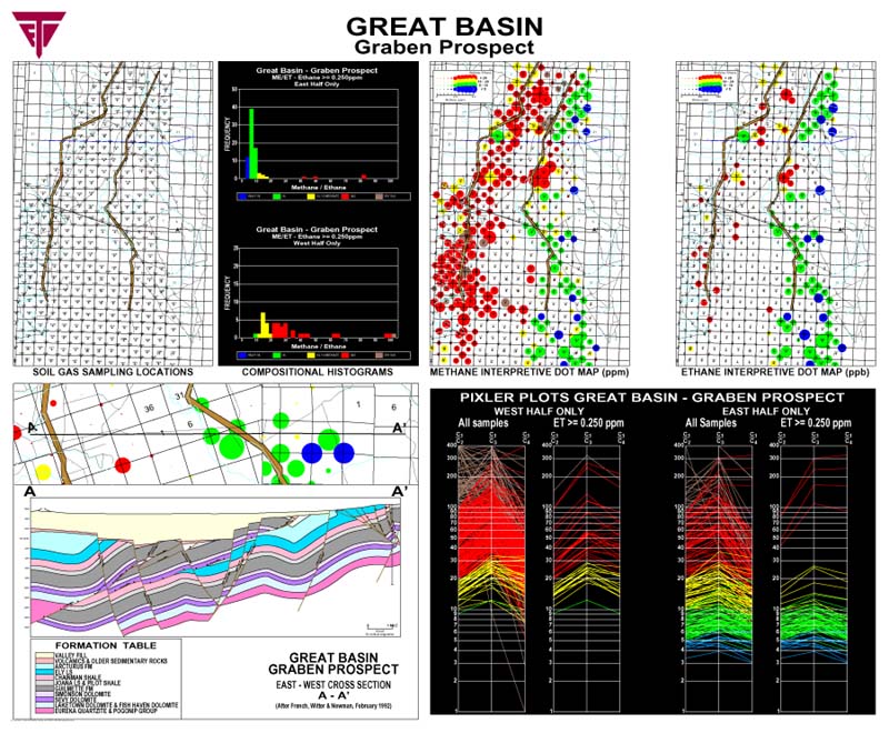
As shown by this regional data set collected on 5000 foot centers within a Nevada Valley, the seepage is basin wide. Soil gas samples were collected on section corners and centers. Methane and ethane dot sizes on the dot maps are proportional to the methane and ethane magnitudes in the four foot deep soil gas samples. Note that the seepage is concentrated along the basin margins, but does exist over the entire basin. There is no known commercial production in this valley, and perhaps never will be. Clearly the source rocks are expulsing hydrocarbons to the surface, defining fairways where reservoirs are likely to form. The soil gas data shows the maturity of the subsurface source rocks in the basin. The colors chosen for the dots are selected from the Pixler ratio plots of methane/ethane ratios of the soil gas data. The data shows that the eastern side of the valley is oilier than the western margin, with much larger ethane observed near the oilier, eastern side of the basin. A geologic cross section explains the compositional changes as they relate to source rock maturity (pink layer) that determines the oil vs. gas character of the reservoirs generated from the source rocks contained in this basin. The light gas ratios (Pixler Plots) have been divided into western and eastern plots to demonstrate the compositional differences expressed by the soil gas seepage across the basin. The color code for the methane/ethane ratio was chosen empirically to fit typical reservoirs, as explained by Jones et al. (1999) and by Jones and Drozd, (1983).
Changes in compositions shown by soil gas data, when properly collected and analyzed, is never random, but is very stable and controlled by the subsurface source rocks, as are the reservoirs. Only the source rocks in a basin can provide such obvious control along with regional changes over an entire basin.
| Home | Exploration
Geochemistry Services | Environmental
Geochemistry Services |
©2002 Exploration Technologies, Inc.